Location: Home >> Detail
J Sustain Res. 2025;7(2):e250027. https://doi.org/10.20900/jsr20250027
 ,
Preye Samson Ingomowei * ,
Olaleke Oluseye Ogunnaike
,
Preye Samson Ingomowei * ,
Olaleke Oluseye Ogunnaike
Business, Entrepreneurship & Innovation Research Cluster, Department of Business Management, Covenant University, Ota 112107, Nigeria
* Correspondence: Preye Samson Ingomowei.
Remote sensing technologies offer valuable tools for flood mitigation strategy and flood monitoring, but their effectiveness is limited by factors such as inadequate infrastructure, limited technical expertise, and the disconnect between technological solutions and local needs. Therefore, this study examines the integration of social innovation with flood remote sensing technologies in developing countries through a systematic literature review spanning 2013–2024. The study explores the systematic literature review on social innovation in reducing the effects of floods, filling the existing gaps, and evaluating the areas of interest when integrating social innovation with flood remote sensing. The study revealed that community based and participatory approaches for engagement in social innovation potentially provide a viable way to enhance flood management. The study will contributes to existing body of knowledge as well as policy makers in flood prone areas. However, further studies could conduct an empirical study to have concrete data and information on how social innovation can be used in flood remote sensing.
Over the years, the occurrences of flood in countries have enhanced in both frequency and severity, and the sustainability of the present management strategies is in doubt [1]. The conventional approaches, which mainly employ the engineering solutions like dams, levees and drains, are however not adequate to manage the increasing flood hazard. These measures often come at a high environmental and social cost, displacing communities and disrupting ecosystems [2]. Flooding, which is a perennial natural disaster has ravaged communities across the globe, leaving a trail of destruction, displacement, and economic hardship. The impact of flooding is often exacerbated by a complex interplay of factors, including rapid urbanization, climate change, inadequate infrastructure, and limited resources for disaster management. A nation with diverse ecological zones is particularly vulnerable to flooding [3]. Each year, floods inundate vast swathes of land, affecting millions of people and causing significant damage to property, agriculture, and critical infrastructure in developing countries like Sub-Saharan Africa [4].
Over the years remote sensing has proven effective in detecting flood-prone areas and monitoring the extent of floods via the use of technological tools [5]. Advance in technology, particularly in the field of remote sensing, has substantially improved the ability to monitor, predict, and manage floods in communities. Remote sensing, a powerful tool for Earth observation, has revolutionized the way flood is been monitored and managed [6]. Remote sensing facilitates more accurate flood forecasting, risk assessment and emergency response by offering real-time data on flood extent, water levels, and land cover changes [7]. Remote sensing technologies use a variety of recording devices to gather information on infrastructure and things on Earth’s surface without having to come into direct touch with them [8]. In situations where direct or physical interaction is not feasible, it is beneficial. Space-based imaging systems, satellites, and Synthetic Aperture Rada (SAR) [9], this method facilitates quicker data collecting. While ground-based observations are not able to collect data as efficiently or precisely, remote sensing technology covers huge geographical regions quickly and efficiently while gathering identical data and offering a complete picture of the target objects [10]. Despite poor weather, it is still able to take pictures of far-off objects. Flood remote sensing has advanced technologically, but there is still a significant gap in the technology’s accessibility, usefulness in at-risk populations, data infrastructure, and ability to analyze and interpret data [11].
Flood losses are a purely economic category. Flood losses do not occur in nature, because floodplains are naturally shaped by periodic floods. Losses occur when technical development appears on floodplains. Therefore, one of the most important factors in reducing flood losses is proper spatial development as well as social innovation. However, this study will be limited to social innovation. Given these challenges, there is a realization of potential innovative and sustainable ways of solving the flooding issue and also on how the remote sensing technology can be implemented to benefit the affected communities. Social innovation, which harnesses the power of collective action and community-based approaches, offers a promising avenue for enhancing flood resilience [12]. Avelino et al. [13] defines social innovation as new ways, perceptiveness, notion, and venturing that meet the needs of society. Often, such innovations promote positive dynamics at the system level, thereby improving the lives of people and society as a whole. In the context of flood remote sensing, social innovation can involve the development of participatory mapping initiatives, community-based early warning systems, and the co-creation of knowledge between scientists and local populations [14]. Social innovation brings a participatory and human-centered approach to disaster management, involving communities, local organizations, and governments in the design and implementation of solutions [15,16]. This collaborative approach ensures that technological advancements are not only accessible but also aligned with the real-world needs of those most affected by floods. In light to understand how flood can be managed in developing nation, mostly in local communities, this study explores literature to investigate how social innovation can be used in floods remote sensing. In order to explore this study, the following are the objectives of the study:
1.
2.
The purpose of this paper is to systematically review social innovation in the area of remote sensing for flood risk reduction. In order to determine the role social innovation play in flood remote sensing as a means of mitigating flood damage in developing countries, a thorough analysis of the literature in this field was conducted. The first step in achieving these goals was compiling a list of the most valid, current, and relevant research articles that had been published in prestigious publications. Furthermore, the basic principles of Systematic Literature Review (SLR) provide enough transparency and reproducibility as a research tool.
The two primary stages of the research article search process are article retrieval and screening. Each of these stages is addressed in depth in the sections that follow.
Article Retrieval PhaseThe article retrieval phase focused on gathering relevant research studies from authoritative sources. This phase involved searching for recent publications that address the integration of social innovation with flood remote sensing. To ensure a thorough and comprehensive collection of relevant literature, we utilized well-regarded academic databases such as: Google Scholar, Scopus, and Science Direct.
The search focused on identifying articles published in top-tier, peer-reviewed journals within the fields of environmental science, social innovation, disaster management, and geospatial technologies. The following keywords and search terms were used: “social innovation flood remote sensing, flood mitigation, community-based flood management, crowdsourcing in flood monitoring, developing countries, social innovation in disaster management and integrating social innovation with technology for flood risk”.
The parameters of the articles included in the study were availability of the articles in the indexed database, relevance of the articles to the field of study, and publication time ranging from 2013 to 2024 to capture the most recent developments and inventions in this field. Only articles available in English were considered for inclusion.
Screening PhaseAfter retrieving a broad range of articles during the retrieval phase, the next step was to screen them for relevance and quality. The screening process was divided into two stages: initial screening and detailed review.
Initial screeningIn the first stage of the article search, the articles gathered were screened based on the Titles and Abstracts to identify those that fit the topic of research. Articles were included if they explicitly addressed the following: Integration of social innovation in flood remote sensing technologies; Application of social innovation in flood mitigation strategies, and the role of community participation in flood management.
Articles that were not directly related to the core themes of social innovation and flood remote sensing, such as those focused solely on technical aspects of remote sensing without social innovation components, were excluded. In addition, duplicate articles were removed during this stage.
Detailed reviewArticles that passed the initial screening underwent a more detailed review to assess the depth and quality of their contributions. Full texts were analyzed to evaluate their methodological rigor, the relevance of findings, and the extent to which they addressed the objectives of this study. Particular attention was paid to:
●
●
●
●
During this phase, articles were systematically categorized based on their contribution to understanding how social innovation can influence flood mitigation through remote sensing. Studies were grouped according to their focus on different aspects of social innovation (e.g., technological innovation, community engagement, data dissemination) and their specific application to flood management.
Data Extraction and SynthesisThe data extraction process focused on identifying key insights regarding:
●
●
●
●
The data extracted from the papers were integrated to formulate a coherent picture of the subject considering the part that social innovation has in flood remote sensing and its application in flooding control. This synthesis process allowed us to identify trends, gaps, and opportunities for further research and practical applications in the field. The overview of SLR is depicted on the Figure 1.
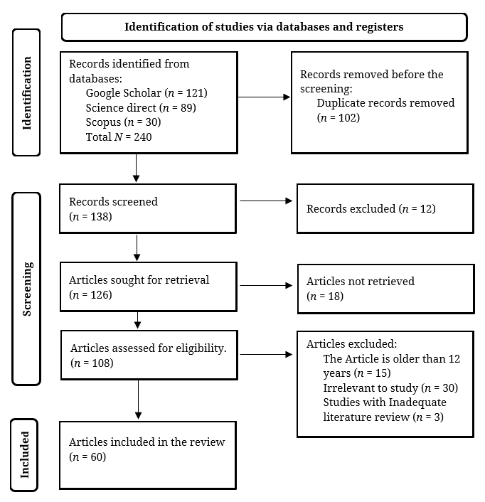 Figure 1. Authors preferred reporting items for systemantic reviews and meta-analyses (PRISMA) flowchart.
The number of reviewed papers on social innovation and flood remote sensing over the 12-year period is presented in the Figure 2 in terms of annual publication. Initially, from 2013 to 2014, there were only two publications annually, indicating early interest. In 2015, publications increased to five, suggesting growing recognition of social innovation’s potential. From 2016 to 2019, publication numbers stabilized between one and three per year, reflecting a period of consolidation and potential challenges. Interest surged in 2020 with five publications, rising to six in 2021 and 2022, and peaking at twelve in 2023. The number slightly declined to nine in 2024 but remains high. This trend shows that research on social innovation in flood remote sensing has significantly grown, emphasizing its increasing importance and integration with advanced flood monitoring technologies.
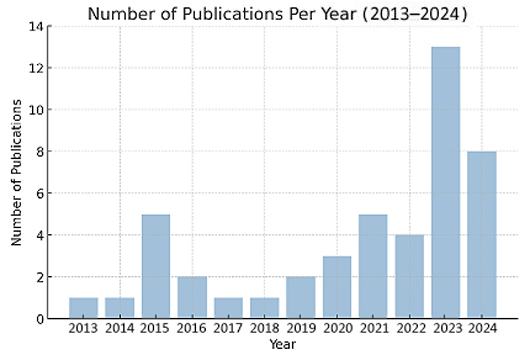 Figure 2. Number of papers published from 2013–2024.
Social Innovation, a concept that emerged as an extension of traditional innovation models, has garnered significant attention in recent years [17]. It is defined broadly as new ways of addressing social needs that are better in terms of performance, longevity, fairness or value than the previous methods, and it delivers value for the collective good rather than individual self-interest. Researchers have over the recent past explored different aspects of social innovation such as definitions and concepts, models, antecedents, outcomes, enablers and limiters [18–20]. According to [21], social innovation is defined as a new concept, strategy or a program that is used to solve social problems in a better way than before. As applied to flood management, social innovation comprises a broad spectrum of actions that present the active participation, cooperation, and engagement of individuals or groups in a society [9,22]. These activities may include developing innovative flood warning systems, promoting community-based flood preparedness and response plans, fostering social resilience through education and awareness programs, and utilizing nature-based solutions for flood risk reduction. Social innovations can be progressive, institutional, or disruptive when measuring social change [23]. The incremental social innovations consist of the newer tools and techniques that are used in monitoring and in passing information on floods. For example, a telemetric system which transmits real time early warning to give adequate time for action which is also considered adequate time for preparing [20]. Whereas incremental social innovations are based on goods and services, the institutional social innovations are based on the market and endeavour to capture or re-orientate extant social and economic systems to create new forms of social value and outcomes [24,25].
The term “social innovation” (SI) is defined by [19], as creative services and activities that address societal needs and are frequently provided by social service organizations. SI is defined as an approach to social difficulties that aims to achieve long-term social welfare outcomes across organizational borders and jurisdictions, frequently with the voluntary participation of civil society actors [18,26]. Three forms of social innovation exist: systemic, which aims to alter organizational structures, attitudes, and values fundamentally; broader level, which addresses societal concerns; and grassroots, which responds to social needs and disadvantaged groups. Expanding upon the concept of using innovation to tackle social issues [27] the term “social innovation” here refers more precisely to the desired results of a technological innovation for the benefit of society or the community (rather than just maximizing profit).
Castro-Arce et al. [28] stated that social innovation efforts help to improve resilience by establishing community networks, increasing adaptive ability, and encouraging sustainable practices. Social innovation efforts can use social capital to mobilize community resources, foster knowledge sharing, and enable collaborative decision-making [14,24]. The Science and Technology Road Map to 2030 was released by the United Nations Office for Disaster Risk Reduction (UNISDR) Science and Technology Partnership during the United Nations Office for Disaster Risk Reduction (UNISDR) Science and Technology Conference in Geneva in January 2016. The program’s goal is to support and promote the use of science and technology to the decision-making process related to disaster risk reduction [29]. Incorporating local knowledge into disaster management decision-making is one of the valued aspects of community-based innovation, in addition to its technological innovation [24]. Numerous research, have examined how SI might enhance flood readiness and have identified SI strategies for small city preparedness and prevention [18,30,31].
Flood Remote SensingThe use of satellite and aerial imagery, along with other remote sensing technologies, to gather data on flood extent, depth, and velocity has become increasingly important in flood management and mitigation efforts worldwide [6]. This data can be used to create flood maps, assess flood damage, and identify areas at risk of flooding [12,30]. In order to rapidly assess the extent and severity of floods, remote sensing technologies offer a synoptic perspective of flood occurrences. Important details on water levels, inundation areas, and flood dynamics are obtained using satellite imaging, aerial photography, and LiDAR (Light Detection and Ranging) data. Assessing flood damage, creating maps of flood inundation, and identifying flood-prone locations have all been accomplished by researchers using remote sensing data [8,10,32]. In general, two sets of remotely sensed data are needed for flood mapping: one set of data is collected prior to the flood event, and the second set is collected during the flood [16]. Typically, the pre-Flood image serves as a point of comparison. It is possible to map inundation zones and draw flood boundaries using this data. In order to monitor changes in surface water extent and gather additional hydrologic data, field observations can be combined with remote sensing data taken from satellites or airplanes [33].
Farhadi et al. [9] stated that remote sensing technologies have undergone rapid development, with a variety of platforms and sensors now available to capture data on floods. Satellite remote sensing is among the most widely used technologies, with different types of sensors providing various levels of detail about flood events. Optical sensors on satellites such as the Landsat series, Sentinel-2, and MODIS (Moderate Resolution Imaging Spectroradiometer) capture images in visible and infrared wavelengths, allowing for the identification of water bodies, flood extents, and changes in land cover [6,31]. These images are useful for mapping flood extents and monitoring changes over time, especially in cases where large-scale floods occur. However, optical sensors are limited by cloud cover and the need for daylight, which can hamper their effectiveness during storm events that often accompany floods.
Satellite imagery and drone data can be used to map the extent of flooding, identify areas that are most severely affected, and prioritize rescue and relief efforts [34]. Real-time flood maps can be integrated into decision-support systems used by government agencies, humanitarian organizations, and emergency responders, providing a common operating picture that improves coordination and response efficiency [14]. For example, SAR imagery was used extensively during the 2017 Hurricane Harvey floods in Texas to monitor flood extents and guide emergency response efforts. Similarly, during the 2020 floods in Bangladesh, Sentinel-1 radar data was used to map the inundation extent and identify regions that required immediate intervention. However, [35] examined flood risk reduction strategies in Nigeria, noting that remote sensing have a crucial role in identifying flood-prone areas and informing mitigation efforts. Another comprehensive review was conducted by [36] focused on remote sensing methods for flood prediction, categorizing the technologies into multispectral, radar, and LiDAR-based systems. This review underscored the importance of accurate flood prediction in the pre-disaster phase, which is essential for effective emergency response and risk management. In order to overcome these constraints, the research also pointed out weaknesses in the available technologies and suggested a flood prediction and extent mapping approach. Similarly, the work by [35] explored the application of remote sensing for flood management in urban Africa, including Nigeria. This study highlighted the challenges and opportunities in using remote sensing data for urban flood management, emphasizing the need for integrating these technologies with local knowledge and practices.
Social Innovation in Flood Remote Sensing in Developing CountriesRecent studies have focused on the development and application of remote sensing technologies to monitor and manage floods. Wehn and Evers [20] stated that community engagement and participatory sensing have an essential role in enhancing the effectiveness of flood remote sensing technologies. Participatory sensing refers to the collection of environmental data by community members using everyday technologies such as smartphones, which can then be integrated with remote sensing data to improve flood monitoring and early warning systems. Several case studies highlighted in the literature demonstrate that involving local communities in data collection improves the granularity and accuracy of flood-related data [11,14,26]. A notable case involves the use of low-cost satellite imagery combined with community-based data collection methods. Local residents are trained to use mobile applications to report real-time flood information, which is then integrated with satellite data to create more accurate flood risk maps. This participatory approach not only empowers local communities but also improves the timeliness and accuracy of flood predictions [10]. According to [37], community engagement fosters a sense of ownership and responsibility among residents, leading to higher levels of cooperation during disaster response. According to [38], community engagement addresses some of the accessibility issues faced by remote sensing technologies, particularly in regions with limited infrastructure.
Khanm et al. [37] stated that incorporating social innovation involves the development of community-based early warning systems. While remote sensing technologies can detect impending floods, these warnings are only effective if they reach the right people in a timely and understandable manner [7]. Ishigaki and Sashida [15] stated that in flood management, a variety of actors—such as government agencies, disaster management authorities, community organizations, private companies, and research institutions—need to work together to manage flood risks effectively. However, these groups often operate in silos, which can limit their ability to share and utilize remote sensing data in a coordinated manner.
Raza et al. [39] identified the role of social innovation in utilizing existing social networks and communication channels to enhance the dissemination of flood remote sensing data. In many flood-prone regions, particularly developing nations like sub-Sahara region, informal social networks—such as local community groups, religious institutions, and neighborhood associations—emerge as pivotal actors in disaster response [37]. These networks facilitate the rapid spread of critical information, particularly during flood events, when formal communication channels may be disrupted or fail to reach the entire population. The study of [14] stated that social innovation initiatives capitalize on these pre-existing networks to improve the transmission and understanding of remote sensing data at the grassroots level. Several studies have demonstrated that by training community volunteers to act as data ambassadors, social innovation enables the effective distribution of flood alerts and information generated by remote sensing technologies [2,22,27,28]. Research indicates that while remote sensing technologies offer valuable data for flood risk assessment, their implementation in developing countries often faces hurdles such as inadequate infrastructure, limited technical expertise, and insufficient funding [20]. One major issue in the implementation of social innovation in flood remote sensing is the disconnection between the technical data provided by remote sensing systems and the practical needs of local communities and decision-makers [15]. Often, remote sensing data is not adequately translated into actionable information that can be easily understood and used by non-experts, such as community members, local governments, and grassroots organizations. There is also tendency for remote sensing to be implemented in a top-down manner, with little input from the communities that are directly affected by floods [6]. This can result in technological solutions that do not fully address the social, cultural, and economic realities of the areas they are intended to help.
In regions with limited technological infrastructure, social innovation can leverage existing community structures and traditional communication networks. As demonstrated by [15] communities can establish local flood monitoring committees that combine basic remote sensing data with ground-level observations. Where digital infrastructure is lacking, hybrid systems can be developed that combine high-tech remote sensing with low-tech community-based monitoring. This approach has proven effective in several developing regions, as documented by [37]. The challenge of limited technical expertise is addressed through social innovation via capacity-building initiatives that focus on knowledge transfer within communities. Castro-Arce and Vanclay [28] documented successful cases where community members were trained as “local technical ambassadors”, bridging the gap between complex remote sensing data and local understanding. The development of simplified interfaces and locally appropriate training materials helps communities interpret and use remote sensing data effectively, as shown in studies by [2]. Social innovation helps bridge the disconnection between technology and local needs by incorporating local knowledge and practices into the design and implementation of flood monitoring systems. Raza et al. [39] demonstrated how community input in the early stages of system design leads to more effective and sustainable solutions. Through participatory design approaches, communities can help adapt remote sensing technologies to local contexts and needs, including developing culturally appropriate warning systems and ensuring that flood information is communicated in ways that resonate with local populations [14]. Resource constraints in developing countries are addressed through social innovation by promoting resource-efficient solutions and mobilizing community resources and voluntary participation. Studies by [22] show how community-based approaches can reduce the cost of flood monitoring while maintaining effectiveness. Local knowledge networks can be leveraged to supplement remote sensing data, providing cost-effective ways to validate and enhance technological solutions [20].
It is important to note that these solutions are not universally applicable and must be adapted to specific local contexts. The success of social innovation in addressing these challenges depends on several factors including the level of community cohesion and existing social capital, the availability of basic technological infrastructure, the commitment of local leadership and institutions, the cultural context and traditional practices of the community, and the severity and frequency of flood events in the region. Research indicates that while remote sensing technologies offer valuable data for flood risk assessment, their implementation in developing countries requires a carefully balanced approach that considers these contextual factors. Ekeu-wei and Blackburn [6] emphasize that successful integration of social innovation with flood remote sensing technologies requires long-term commitment and sustained community engagement.
Studies have identified that developing countries face unique challenges, such as high vulnerability to flooding due to socio-economic factors and inadequate early warning systems [17,36,39]. However, there is a notable lack of comprehensive models that integrate social innovation with technological solutions in flood management. Existing research often overlooks the importance of cross-sector collaboration and the need for tailored strategies that address the specific needs of different communities [15,16,24]. Overall, while there is growing recognition of the potential benefits of integrating social innovation with flood remote sensing, current research emphasizes the need for more robust frameworks that address the specific challenges faced by developing countries.
The study highlights the significant role of social innovation in enhancing flood remote sensing, particularly in developing countries. Traditional flood management strategies, heavily reliant on structural measures, have proven insufficient given the increasing frequency and severity of flood events. This inadequacy is compounded by high environmental and social costs and the limitations of conventional remote sensing technologies. Significantly, it should be recognized that flood losses are fundamentally an economic category rather than a natural phenomenon. While floodplains are naturally shaped by periodic floods, losses only occur when technical development encroaches on these areas. Therefore, proper spatial development emerges as one of the most crucial factors in reducing flood losses, alongside social innovation approaches. Social innovation, which involves collaborative, community-based approaches, offers transformative potential for improving flood management. It addresses the gaps in traditional flood remote sensing by incorporating local knowledge, enhancing community engagement, and fostering more effective communication channels.
Key findings from the literature indicate that participatory sensing, community-based early warning systems, and the use of social networks for disseminating information can significantly improve the effectiveness and accuracy of flood remote sensing technologies. The integration of community input not only enhances the granularity of flood data but also increases the timeliness and relevance of flood alerts. This is evidenced by studies such as [10], which demonstrated how local residents trained in mobile applications can effectively report real-time flood information that integrates with satellite data to create more accurate flood risk maps.
Despite these advancements, several challenges remain in developing countries, including inadequate infrastructure, limited technical expertise, and insufficient funding, as highlighted by [11] and [16]. A significant issue is the disconnect between technical data from remote sensing systems and the practical needs of local communities and decision-makers. The research by [15] emphasizes how this gap affects the effective utilization of flood management technologies. To address these challenges, the evidence suggests several promising approaches. Studies by [14] and [37] demonstrate the effectiveness of leveraging existing social networks and community organizations in flood response and information dissemination. Additionally, research by [28] shows how social innovation initiatives can successfully capitalize on pre-existing networks to improve the transmission and understanding of remote sensing data at the grassroots level.
The findings point to the need for greater collaboration between scientists, technologists, and local communities, particularly in developing countries. This collaboration should focus on building local capacity for data interpretation and technology utilization, as suggested by the work of [2] and [27]. Future research could benefit from empirical reviews of social innovation in flood remote sensing in rural communities, particularly focusing on how flood-prone developing countries can better utilize social innovation to understand and implement remote sensing technology. Also, more research is needed to develop comprehensive models that integrate social innovation with technological solutions while addressing the specific socio-economic contexts of different communities.
In terms of best practices, based on the findings and review of literature, there is a need to emphasize the importance of crowdsourcing and collaborative platforms for enhancing flood remote sensing in communities. Crowdsourcing allows for the collection of vast amounts of data from diverse sources, improving the accuracy of flood monitoring. Collaborative platforms, which bring together government agencies, community organizations, and private companies, facilitate the sharing of remote sensing data and ensure that all stakeholders are working from a common operating picture. These practices not only improve flood response but also contribute to long-term flood resilience by fostering collaboration and trust between different sectors.
There is a need for public-private partnerships as a promising avenue for leveraging social innovation in flood remote sensing. These partnerships can help bridge the gap between the availability of remote sensing technology and its effective application in communities at risk. By pooling resources and expertise, public-private partnerships can develop more effective and sustainable flood management systems that are tailored to the needs of local communities. However, to fully realize the potential of social innovation in flood remote sensing, there is a need for greater collaboration between scientists, technologists, and local communities, as well as more targeted efforts to address the challenges of data interpretation and capacity building in developing countries.
This systematic literature review provided guidance on the topic of social innovation in flood remote sensing; however, there have been limitations during the course of the study. The concept of developing countries used in the analysis can encompass a great number of countries, and the differences in the technological advancement, social systems, and flood management strategies at regional and economic levels can be masked, reducing the generalizability of research findings to some particular context. Also, the theoretical nature of this review, while providing a comprehensive overview, lacks empirical validation through field studies and practical implementation data, which would be crucial for validating the proposed frameworks and recommendations. The lack of such empirical research poses difficulties for evaluating the practical effectiveness of linking social innovation with flood remote sensing in various cultural and economic settings, especially where organisational difficulties could be more evident as resources may be scarce.
Data sharing does not apply to this article because the study performs a systematic review through a synthesis of existing literature on social innovation in flood remote sensing. The study obtained its sources from academic publications and conference proceeding along with institutional reports that can be accessed through the manuscript references section.
Conceptualization, OOO; Methodology, IPS; Validation, OEM; Formal Analysis, IPS; Investigation, IPS; Resources, OOO; Writing—Original Draft Preparation, IPS; Writing—Review and Editing, IPS; Visualization, OEM; Supervision, OEM; Project Administration, OOO. All authors have read and agreed to the published version of the manuscript.
The authors declare that they have no conflicts of interest.
The authors acknowledge the support from Covenant University Centre for Research, Innovation and Discovery (CUCRID) Covenant University, Ota, Nigeria, for the funding opportunity given during the preparation of this manuscript.
1.
2.
3.
4.
5.
6.
7.
8.
9.
10.
11.
12.
13.
14.
15.
16.
17.
18.
19.
20.
21.
22.
23.
24.
25.
26.
27.
28.
29.
30.
31.
32.
33.
34.
35.
36.
37.
38.
39.
Ogbari EM, Ingomowei PS, Ogunnaike OO. Demystifying Effect of Social Innovation in Flood Remote Sensing: A Schematic Review. J Sustain Res. 2025;7(2):e250027. https://doi.org/10.20900/jsr20250027

Copyright © Hapres Co., Ltd. Privacy Policy | Terms and Conditions


